Dingwall city centre
Golspie Big Burn Walk
Sitka looking majestic for his photo
After our tea in Dornoch we took in some air on the beach looking out to the Dornoch Firth, the weather was great and no midges made it even better.
Lesley and Sitka having great fun on the beach
First attempt at astrophotography, not bad considering the Fuji was perched on the car roof

After leaving Dornoch we headed up A9 stopping off at Helmsdale, wanting to see The Emigrants statue, words cannot do it justice, so lifelike and strangely haunting, fleeting thoughts of the hell these people must have endured at the hands of the Duke of Sutherland.
Clearances took place throughout Sutherland and are remembered as the most notorious of all the clearances throughout the Highlands. The Strath of Kildonan runs north west from Helmsdale for over twenty miles. Today there are very few houses in the strath but two hundred years ago it was very different with a relatively large population living in many small scattered communities throughout the glen. In 1811 the population was recorded as 1,574. Between 1813 and 1819 the strath was forcibly cleared of its inhabitants. Many went to live in the new settlements built on the coast but others decided to emigrate to the new world. Many left for Canada, and it was Kildonan settlers who founded what is now the city of Winnipeg in Manitoba. By 1831 the population of the Strath of Kildonan was reduced to just 257 people.
Our next stop off was the Camster Cairns. These are two large Neolithic chambered cairns located about 8.5 miles (13.7 km) south of Watten and 5 miles (8.0 km) north of Lybster in Caithness, in the Highland region of Scotland. They are among the oldest structures in Scotland, dating to about 5,000 years ago. The cairns demonstrate the complexity of Neolithic architecture, with central burial chambers accessed through narrow passages from the outside. They were excavated and restored by Historic Scotland in the late 20th century and are open to the public.
A bit of a tight squeeze to get in, Neolithic man being a tad more athletic build I guess
The Whaligoe Steps were our next stop, so glad we didn't stop last year on the bikes as it wouldn't be easy in bike gear. The Whaligoe Steps is a man-made stairway of 365 steps (316 according to Lesley)that descend to what was a naturally formed harbour between two sea cliffs - once a landing place for fishing boats. The steps are located just south of the town of Wick in Caithness on Scotland's most north easterly coast. They date originally from the mid-18th century and were once used by fisherwomen to haul up the creels of herring landed at the harbour beneath. Crews of women, some in their early seventies, would gut the fish, Herring, cod, Haddock, or Ling and would carry them up the steps in baskets to be taken on foot to be sold in Wick, some 7 to 8 miles away. Barrels made in the cooperage at the top of the cliffs were taken down for salted herring to be stored in then taken away by schooner. Although a popular attraction today, 'Whaligoe Steps' is notoriously difficult to find as the steps are not signposted on the main road as we can testify to, once passed its not easy to find a turning to head back.
Lesley and Sitka leading the way
Old pulley for hauling in the boats
Must have been pretty wild trying to land a catch here, Whaligoe, (whale geo or inlet of whales) is a small port which was prospected by Thomas Telford in 1786 during his tour of northern fishing harbours for the British Fishing Society. His judgement of the place was that it was a "terrible spot".
Elephant rock, my made up name for it but it does have a passing resemblance to one
Time to head on our journey North
Dunnet Head Lighthouse, our lighthouse visits continue around the country

The view from Murkle campsite towards Dunnet Head was much nicer than the view of the site, no wonder there weren't any reviews at all on the internet, the Dunnet campsite 2 tent pitches full to the brim, we were then left with a sodden wet field, the toilet/shower block was a workies portacabin with some wooden slats nailed in a fashion to hide the years of decay
The nearest food and beer was in Thurso, thankfully not too far away. After our tea we headed back to the site to while away the evening sitting in the car (it was raining by this time) listening to Bob Dylan and partaking of McEwans Export by the tin and whisky in plastic tumblers just to keep with the mood of the place.
Time to head back South down the A897 stopping at the RSPB nature reserve in Forsinard. We went into the railway station that is used as a visitor centre for the Forsinard Flows for a cup of tea and a watch of their wildlife film. An easy walk along the wooden boardwalk as it weaves its way through the flat peatland to the lookout tower.
Old railway switchgear adorning the window
Forsinard railway station
Ben Griam Beg to the right and Forsinard tower on the left
Lesley and Sitka enjoying the sunshine again
The tower seems to fit into the landscape
The blanket bog of the Flows flowering in the sunshine
Lesley's Titanic moment
A very fast swallow having fun darting about
A pair of swallows feeding off the insects in the bog
Our last nights stop was at Fortrose campsite, just in time to see the dolphins said the wifie, pinch of salt taken I thought. Once the tent was up we decided to head along the stony beach to Chanonry Point beyond the lighthouse for a look.
Sitka getting his pre dolphin show ice cream
Chanonry Lighthouse
The assembled throng of dolphin watchers
Even with the amount of people heading that way I was still thinking dolphins aye right. It wasn't long before some of the assembled throng spotted something in the water, lots of cameras poised for porpoises, low and behold they did appear, 2 of them making an appearance for what seemed like an hour or so playing up to the crowd, we felt so lucky to see them in their natural habitat.
Dolphin and sailing boat
Happy dolphins
A cheeky seal getting in on the act
A pre tea walk along the beach of Rosemarkie Bay
Sitka happy again he's the centre of attention
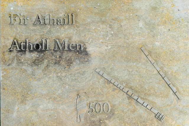
The projecting stones up to about 6m represents the government troops killed, the stones onward stretching to the far end represent the Jacobites killed
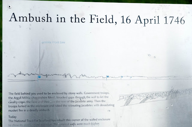
The battlefield
Leanach Cottage
It doesn't bear thinking about how it would have felt standing here on that day with the rain and sleet hammering into you as you faced your enemy
Lesley and Sitka paying their respects standing in the Jacobite line
This grave stone sums up my feeling of the place, so few words that have such emotions
I cant wait till our next Scottish trip, bike or car, East, West, North or South its such a beautiful country to explore.


No comments:
Post a Comment